Friday, 24 July 2015

Porthmadog to Criccieth - 29 October 2014 - 8 miles on foot

It was an early train to Smethwick Galton Bridge and a 15 minute wait before catching the Arriva Trains Wales service to Machynlleth, where I changed trains, arriving at Porthmadog at 10:49.

The dominating feature on leaving the train was the factory-like Tesco supermarket that did allow me to stock up with provisions prior to my walk.  The sky was blue, the wind light and the temperature was to be expected for a late October day.

Porthmadog itself was somewhat drab for what I would regard as a resort.  The shops on the main streets were original but appeared unloved.  There were no architectural atrocities with the exception of the aforementioned Tesco - but, even in Porthmadog, people have to eat!

Porthmadog Harbour

Reaching the harbour, my mood was lifted by the sight of the boats, the sound of the rigging and the smell of the sea.  I followed the track alongside the Afon Glaslyn and the boatyards until the lovely village of  Borth y Gest was reached (11:35 - 1.5 miles).  The setting is sublime - The typical Welsh stone cottages almost dip their toes in the small tidal cove surrounded by green.

Borth y Gest

The path took me over low cliffs and sand dunes until the wide expanse of Black Rock Sands was reached (12:00 - 2.5 miles).  The sands made up the longest part of the walk and holiday makers were enjoying the few remaining days of good weather until the onset of winter.  The sands are also accessible to private cars and many drivers had ventured onto the sands, parking their vehicles well above tide's reach.

Black Rock Sands
For most of the walk along the sands, the beckoning hill top castle of Criccieth remained in constant view.  At the hill of Craig Ddu, it was necessary to venture inland, where I could enjoy the view towards Snowdonia from a higher vantage point.

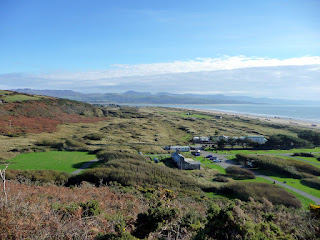
View from Craig Ddu

After a little while, I crossed the railway line (1308 - 5.2 miles) and walked alongside green meadows before recrossing the railway and continuing into Criccieth on the beach side track, reaching the castle at 1340 (7 miles).

Criccieth

I had plenty of time to walk around the lovely town, eat my lunch of fish and chips at the cafe in Castle Street followed by an Ice cream from Cadwaladers across the road before walking the final yards to the station where I caught the 15:51 train home.

Thursday, 23 July 2015

Harlech to Porthmadog - 22 July 2015 - 10 Miles by Bike

Another very early start to catch the first (6:30am) train out of Smethwick Galton Bridge for my journey to Harlech, changing at Machynlleth to travel along the scenic Cambrian Coast Line.  I had delayed this journey for some time whilst waiting for the Pont Briwet Bridge to be rebuilt following storm damage a couple of years or so ago.  The rail bridge had been opened opened a few months earlier, but I had to wait until two days before my journey for the road / bike / pedestrian route to be available.

Harlech Castle

The train arrived at Harlech on time at 10:25 and soon I was cycling, or rather walking up the steep hill next to old grey stones of Harlech Castle.  The sky was overcast and there were a few people around, but the expected hoards of tourists were thankfully missing.  Harlech is an attractive small town containing a mixture of stone and whitewashed houses.  At the crossroads, I turned left onto the B4573 and was quickly hurtling downhill out of Harlech with trees on both sides and occasional glimpses of Glaslyn estuary on my left.  Soon, the road leveled out onto the coastal plain and I continued to Tygwyn (11:10 - 3.5 miles).

At Tygwyn, I joined the surprisingly quiet A496 and pedaled on to the village of Talsarnau which lined the road with stone and whitewashed cottages and the occasional chapel.

Talsarnau

Continuing along the road, I reached the turning to the rebuilt Pont Briwet at Llandecwyn (11:26 - 5.8 miles).  Except for work continuing on the approach roads, the bridge is now complete and offers excellent views upstream for walkers or cyclists.  The downstream views are better appreciated from the train!

View from Pont Briwet


Onwards to Penrhyndeudraeth (11:40 - 6.5 miles) where I met a couple of visitors from London who were looking for Snowdonia.  I pointed them towards Ffestiniog and continued on my way into the village, another well kept hamlet similar to those I had already passed through.  The village did possess a few interesting features including a nicely painted green corrugated iron shed, a railway bridge and three ancient tractors.

Penrhyndeudraeth
Shortly after leaving the green shed, I cycled under the Ffestiniog Railway (11:53 - 7.8 miles) through a narrow stone arch.  Despite hearing noises in the distance, the picture I took does not include a steam train.

Ffestiniog Railway bridge

One of the tractors I encountered soon afterwards looked as though it had just emerged from the showroom.  The other two were in a ruinous state.

Pristine tractor

I continued to the Cob, the causeway which takes both road and Ffestiniog Railway over the Glaslyn River to Porthmadog.

View from The Cob
Arriving at Porthmadog (12:20 - 10 miles), I had a real treat as a steam train made its way across the main road and continued on its way towards Ffestiniog.

Ffestiniog Railway
It was then time for food.  I visited Allports Fish and Chip shop and devoured my purchase at the nearby park, close to the Ffestiniog Railway and overlooking the Glaslyn Lake.

I had plenty of time before my train at 2:00, so I visited the Station Inn for a pint before my uneventful but punctual return train home.

Sunday, 14 June 2015

Mynydd Cilan to Abersoch - 5 miles on foot

Tuesday 26 May 2015

As usual with a one day walk in Wales, I took the early train, arriving at Pwllheli at 1205 and took the 18 bus to Mynydd Cilan towards the south west end of  the Lleyn Peninsula.  I arrived at just after 1300 and began my walk, initially through the village of Nant-y-Big (1315) and onwards to the coast path.

Converted chapel at Mynedd Cilan

The day was pleasant, but cloudy with a slight breeze - ideal for walking, really.  The way sloped downwards to the broad sandy beach as I walked accompanied by a number of families with small children equipped with appropriate tools for building sandcastles.

Porth Ceiriad Beach

Soon our routes parted and I continued up the slope where I had excellent views of the beach below and the cliffs ahead towards the headland at Trwyn yr Wylfa (1330).  The undulating path took me past the islands of St Tudwals, where I was delighted to see several dolphins swimming and occasionally leaping out of the water.  These creatures were pursued by groups of tourists in small boats trying to capture the show with there cameras.  I believe my vantage point was both better for viewing and kinder to the dolphins.

St Tudwals Islands

Gorse bushes and Snowdonia

I continued along the coast path past bright orange gorse bushes to the village of Machroes (1420) which boasted several white painted stone cottages and an old boathouse tucked in between the sand and the cliff.  By now, the weather had warmed up and there was some sun.  This appears to have brought out the holidaymakers who were either lazing or cavorting along the stretch of sand all the way to Abersoch (1440).

Machroes boathouse

I had a little time before my bus was due to arrive, so had my usual fish and chips followed by a cornet of local icecream.  It was then time to make my way back to Pwllheli and the train home.

Saturday, 3 January 2015

Llanrhystud to Aberaeron - 14 April 2014 - 8 miles on foot

I appear to be slipping into bad habits.  This is my first blog for some time, although I am still continuing to manage about one outing each month.  Thus chastened, I shall try to write up each blog soon after the journey and catch up on all the other trips I have not yet written about.

The early (0630) train from Smethwick Galton Bridge brought me into Aberystwyth on schedule at 0915.  The First number 40 bus departed from opposite the Railway Station and deposited me in Llanrhystud outside the Black Lion Inn at 1000, where I had completed a previous walk (details later).


I spent a few minutes exploring the narrow streets, whitewashed stone cottages and attractive church with a tower before moving on my way.  The weather was cool, but bright and occasionally sunny - perfect for walking.

I walked down the main street and along a narrow lane past sheep and lamb filled fields against a backdrop of gentle wooded hills.  Within 1 mile (1021), I arrived at the grey pebble and shingle beach backed by low cliffs that rose from the end of the lane.


My walk took me along the Wales Coast Path across fields, passing some abandoned stone-built lime kilns.  I soon reached the village of Llansantffraed.  This time, the equally attractive stone church with slate wall hangings had been built with a tower.  After some refreshment, I walked through the village of whitewashed stone cottages and into the neighboring twin village of Llanon  (2.5 miles - 1115).


Llanon, situated on the main road was noisier than and not so tidy as its neighbour.  Outside the village, there was a development of new houses.  To the credit of the developers, they were built in the local style with rendered walls painted in a variety of attractive colours.  The prices looked reasonable too!


Onwards along another lane to the seafront and the uninspiring Hotel Plas Morfa.  The path continued along low earth cliffs an over the occasional streams with stepping stones.  Ahead, the path rose over higher cliffs, but there was always the comforting view of Aberaeron ahead of me and New Quay in the distance.

A pleasant undulating walk and I was descending into the village of Aberarth (6 miles 1231).  The village had sparkling streams and multi-coloured cottage - a very pleasant place to live.


Moving forward, the coast path remained level and I soon reached the caravan site that marked the beginning of Aberaeron, my destination.  (8miles - 1317).  I spent some time rediscovering this town since my last visit in 2010.  Aberaeron is famous for its harbour and multi-coloured houses.


All too soon it was time to catch Richards X50 bus to Aberystwyth, a meal at the station (Wetherspoons) and the 1730 train back to Birmingham.  All in all, an excellent day out.

Ramsgate to Margate on foot - 2 February 2013

My original plan for the day was a walk over the White Cliffs from Dover to Deal.  However, the forecast of very strong winds for the day would have meant a far less than agreeable walk, to say nothing of safety.  I modified my plan to walk a stretch of the coastline I had already covered on the venerable bike.

Leaving Coventry at 6:51, the train was early (7:50) into Euston.  A brisk walk over to St Pancras and I was on board the 8:14, arriving at Dover by 9:20.  (Not bad for less than £8).  My change of plan meant a short wait in Dover before my train arrived to take me to  Ramsgate, where I duly arrived at 1040.

Ramsgate Station is about a mile away from the seafront which made for dreary walking past row upon row of dreary terraced housing.  At some time in the past these houses would nave looked alike, making for a harmonious whole, but in the interest of individuality, cheap renovations and extensions have made the place look a mess.  As I approached the seafront, things looked up and I came across more attractive level of architecture.


On reaching the seafront, there were a number of large and attractive hotels and a delightful square of coastguard cottages.  The view over the beach and towards the harbour to my right were excellent. On the downside, the strong wing made its presence felt in comparison to the sheltered narrow streets.

Onward then along the promenade and through Winterstoke Gardens, (A broad swathe of grass with a mock Grecian pavillion and into King George VI Memorial Park (An even broader swathe of grass with trees).


Dumpton arrived with some interesting architecture and the English terminal of the cross Channel telephone link.  The building looks diminutive and old, but I am informed that it remains in service as a fibre optic connection with Belgium.

Broadstairs is a splendid unspoiled place with many ancient buildings blending in well with the Victorian.  It has an air of calm superiority about it and is a place I intend to return to when I have completed the coastal journey.


Walking out of Broadstairs along the the beach, I passed a yellow door in front of a cave in the cliff.  The sign on the door read "Bay Inspector's Office" and the company "Thanet Leisure Force".  My only thought was "To Hell with the standard of office accommodation, I appear to have missed my vocation somewhere along the line!"


I climbed the steps up the cliff to the road and a little further on entered the North Foreland Private Estate.  Despite the OS map showing the route of the footpath along the busy road, it is more pleasant to walk through the estate past large and expensive houses and there are no indications to the contrary.


Emerging from the Estate, I rejoined the cliff top path and walked past the impressive looking Kingsgate Castle, now converted into apartments.  Turning east by the small fort at White Ness, I was greeted by a windy blast which slowed my progress for the remainder of the journey.


The grassy strip between Cliftonville and the sea would have been a pleasant walk on almost any other day, but I pushed on through the wind into Margate, a town which has clearly seen better days.  Many of the buildings appeared to be in poor condition and seemingly little progress was in evidence to restore this resort to its former glory.  Wandering around the town, I was impressed by the railway station and little else.


A meal and a pint at Wetherspoons was followed by a bus journey back to Ramsgate and the train home.